Welcome!

Welcome and thanks for stopping by.
My reference links will open in a new tab.

If you have any corrections, suggestions, comments please use the Comments at the end of the post.
I do respond to all comments. - Thanks!
Showing posts sorted by relevance for query Blue sun cave. Sort by date Show all posts

October 25, 2017

The Blue Sun Cave - Anza Borrego

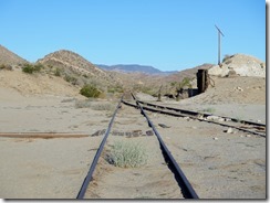
We left Borrego Springs heading to Ocotillo at the southern end of the park.   The antique cars were out for a Sunday drive as they returned home from Borrego Days.  Our destination for the night will be the Mortero Wash staging area.  This is the wash leading to the Impossible Railway and the trail head to our ultimate destination.
IMG_6010 (1280x933)IMG_6016 (1280x955)
IMG_6015 (1280x959)IMG_6017 (1280x959)

In Jerry Shad’s Afoot and Afield in San Diego County he had this to say of Indian Hill (in my 1995 revision): “Several rocky hills consisting of desert-varnished granitic boulders punctuate the surface of this plain.  One of these is Indian Hill – which is incorrectly labeled on the Sweeney Pass topo map.  The true Indian Hill, a site of Indian occupation, has a fire-blackened cave and morteros on its northeast side.”  Google Maps has inherited the misinformation and also has Indian Hill at the same wrong location.  I have not seen any of the Anza Borrego State Park maps that show Indian Hill at all, correct or incorrect.  I think this may be intentional to preserve this delicate feature.

This was not much information to work with and I really have made no effort to locate the true Indian Hill.  I have hiked to the trestle, the lime stone mine and the railroad camp … all of these back-in-the-day when we could get away with hiking on the railroad tracks, but did not attempt to locate Indian Hill. 

But then perhaps unintentionally Diana Lindsay let slip the distance and direction of the true Indian Hill from the one marked on maps.  With the aid of Google Maps and a bit of research I fairly quickly had 3 candidates for a pile of rocks within an area with piles of rocks. 

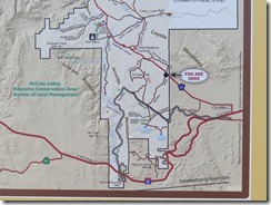
Where Google thinks Indian Hill is.
Capture

What you’ll need:
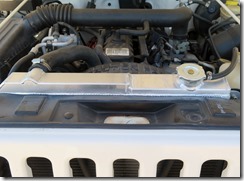
Reliable 4x4 with high clearance, check out the new radiator in Fran’s Jeep.  Just showing it off since I forgot to include the picture in the Borrego Days blog.  It’s a 3-core beauty!
IMG_6019 (1280x946)

Lots of water!  When the Railroad tracks were available for hiking we’d stash water in the tunnels to lighten our backpacks and have cool water on the return.  That’s not an option anymore.
A GPS is helpful, after awhile all the hills will look alike.  If you feel lost remember the railroad tracks are east, when you reach them turn right.
The usual hat, sunscreen and camera with extra batteries, and of course more water!
There is no cell service in this area, you’ll need to be self contained and prepared.
Note that it is currently illegal to drive across the railroad tracks!  Back-in-the-day that was not a restriction.  Any research that mentions crossing the tracks is out of date.

For most folks the trailhead will start at the Dos Cabezas Railroad Siding at the end of Mortero Wash.  High clearance is required (I’d recommend 4x4), this can be a moderate 4 miles, which is mostly hard packed with lots of rocks, some bigger and sharper than others.  From here the trail is ~6 miles out-n-back.  
IMG_6020 (1280x943)IMG_6021 (1280x960)
IMG_6024 (1280x959)

I also had a plan to shave 4 miles off this route – 4x4 lo range was required.  Wile E would have fun!  Fran's TJ made it through, oh we did backtrack to a bypass :)
IMG_6025 (1280x960)IMG_6026 (1280x960)

Again note that it is currently illegal to drive across the railroad tracks!  Ownership of the tracks and its resources changed again in 2016.  So foot traffic only!  Although it’s a bit of an effort to get to this crossing legit, it is definitely worth it to shave 4 miles off the customary route and on a hot day for the hike it's worth the effort ... and a good test of the new radiator!

Apparently not all 4x4 drivers are literate as these look like fresh tracks on an illegal offroad trail.  But the wash is easy to follow, and we ignore the tire tracks.
IMG_6027 (1280x959)IMG_6028 (1280x959)

The first pile of rocks does not fit my notes.  Although there appear to be some pictographs we did not explore.   The next pile of rocks was closer but not the ones we were looking for.
IMG_6029 (1280x929)IMG_6030 (1280x960)

Ah the next pile was spot on!  Tossing my backpack it was a bit of a rock scramble up to the entrance to the Cave of the Blue Sun.
IMG_0920 (960x1280)IMG_0921 (960x1280)
IMG_0923 (960x1280)IMG_6036 (1280x960)

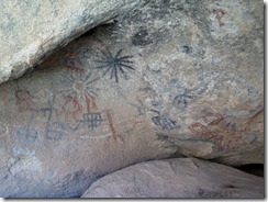
Indian Hill contains several caves (I entered 3) all with some pictographs, but none as extensive as the Cave of the Blue Sun.  The Blue Sun is in the upper left of these pictures, protected from the weather and in the shadows.  Perhaps this is the artist's rendition of a total eclipse ????
IMG_6034 (1280x960)IMG_6035 (1280x960)
IMG_6040 (1280x959)IMG_6042 (1280x959)
IMG_6043 (1280x944)IMG_6044 (1280x959)

There are many other articles on the Internet of this area. 
The Anza Borrego Net is a contribution blog. 
I like Kevin Price pictures as he uses DStretch to extract the hidden highlights of each pictograph.
Guy Starbuck also has some nice shots.

I have not included any of the numerous Yoni symbols that are seen on some of the other blogs, nor did I hike around to the refuge shelter on the other side of Indian Hill.  It was hot and getting hotter, toward record hot!  Maybe another time ...

If you like I’d be happy to critique your research over a glass of wine, I’ll not put anything more in writing that will disclose the location of this delicate treasure.   I’d request that you do the same, once you’ve found it.  After all, the research is part of the challenge!

Allow time to visit the Dos Cabezas Lime Stone Mine and a the remains of the railroad workers encampment.  A nimble hiker may want consider an outing to the Goat Canyon Trestle

We'll be off-the-grid in Mexico for the next week or so... it's time for Dia de los Muertos and the annual Shrimp Festival in San Felipe.  Blogs to come ....

February 10, 2019

Piedras Grandes - my search for the Horse and Rider

The Piedras Grandes Cultural Preserve is approximately 2000 acres set aside to preserve the rich Kumeyaay history found here.

The turnoff from S2 is Mortero Wash which is marked as an access point to visit the Dos Cabezas Railroad Station on the Impossible Railroad.  The Mortero Wash road from S2 is high clearance and 4x4 required!

Trail heads from here lead to the Piedras Grandes (Big Rocks), the mortero springs and palm groves, the Blue Sun Cave and the Goat Canyon Trestle.  Huell Howser was a TV personality for PBS with a weekly video blog California’s Gold.  The archives of his shows are maintained by Chapman University.


The link to Huell’s trip to the Goat Canyon Trestle can be found HERE.  Times have changed, the railroad has changed hands several times, but has never given up their right of way, which is 10' either side of the center line of the tracks.  To reach the trestle today follow Josh’s route HERE.
Back-in-the-day the Impossible Railroad took passengers between Yuma and San Diego in scenic luxury.  While the steam engine took on water for the long climb over the mountains, the passengers could enjoy the comforts of the station, including its outdoor plumbing.


After crossing tracks, I hike the Mortero Wash for a mile to the entrance to the preserve.


Yup this is the glyph I’m looking for, I call it the ‘Horseman’, but officially known as 'Horse and Rider'.  The only known rendering in the park of a man on horseback.  This represents the first contact with the Spanish.

There are lots of cool looking rocks within the preserve.  I do think it would be fun climbing the rocks and leaving a sign marking your special place.  Kinda like carving initials in a tree, or tagging.

About a half mile from the trailhead is a 'Yoni' carved into the rock  A yoni is a natural rock inclusion that has been modified into a female fertility symbol.

Near the yoni are several small caves.  The light coming in from the far side of this little shelter made it particularly interesting,
Along the main trail to the pictographs are several sign boards
The colorful pictographs shown on this signboard are captioned as found in the Blue Sun Cave.

Lots of challenging rock to climb.  As the trail starts gradual uphill to another sign board.
The rock shelter would be fun to find, but in reality I'd not want to squeeze into it.

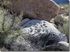
This is a fantastic little cave with what could be an alter in the center.  On the top of the alter, ceiling of the cave and walls surrounding the cave are cupules.  I can only image the ceremonies that might have taken place here.


Most if not all the pictographs in Piedras Grandes are in very poor condition, suffering from long term exposure to the elements.

Another cool shelter

I took a break here to enjoy my PB&J burrito, only to discover I left it on the counter at home.  At the time I was just hungry and ready for a break, now I'm famished and exhausted!

The Horseman is listed as a 3-mile RT from the parking lot.  That is not correct as the parking is now at the railroad siding 2-miles RT away.  If I'd looked closer at the sign at the trailhead I would have known the park literature is incorrect.  It's 1 mile to the trailhead, 1.5 to the horseman = 5 miles RT.

Back-in-the-day the park maintained ramps to allow safe crossing of the tracks.  The ramps have mostly been removed, and it is no longer permitted to drive across the tracks.

Despite not being permitted there are places where ambitious off-road enthusiasts have gathered stones to create a crossing

I took a detour on the way home to Borrego Springs to meet George and Suzi of Our Awesome Travels, who are spending the week at the Peg Leg Smith boon docking site.  We've been following each other's blog postings for a few years, and this seemed like a good time to meet.  And so glad I made the detour!  A very enjoyable couple who have been full-timers for over a decade.  We shared some great stories and places we've visited.  I stole this picture from their website - Thanks George!


This was a fun outing made even better meeting 'old friends' for the first time. 
Certainly No Bad Days!