About Rufus

Pages

January 30, 2020

Yuha Desert - Intaglios and a well

Of the blogs I read, only a search on the Armchair Hiker San Diego finds Yuha in the Search Bar.  Not a very popular destination!  The Yuha Desert is located on BLM land south of I-8.

The map shows 7 sites worth a visit:

1.  Overlook
2.  Yuha Well
3.  Yuha Desert
4.  Yuha Geoglyph
5.  Fossil Shell Beds
6.  Crucifixion Thorn
7.  Historic de Anza Campsite

My weekly BLM NewsBytes (Issue 886) contained this article:

<quote>
New Audio Tour for the Juan Bautista de Anza Historic Trail
Want to learn more about the Juan Bautista de Anza National Historic Trail? A new audio tour and map for the trail through Imperial County are available on our website! The 1,200-mile Juan Bautista de Anza National Historic Trail commemorates, protects, marks, and interprets the route traveled by Anza and the colonists during the years 1775 and 1776 from Sonora, Mexico (New Spain), to settle Alta California and establish a mission and presidio at today's San Francisco, California. (BLM Facebook)
<end quote>

Follow the BLM Facebook link to listen/download the audio and/or download the map.

I have been to the intaglios and the Anza viewpoint in the past, but not the other points of interest.  With the release of the commentary, now I have a perfect excuse for a day trip!


I entered the Yuha Desert on CA 98.

and started the Juan Bautista de Anza National Historic Trail on BLM Trail 274.
This is also the main east/west trail through the desert.

The kiosk has good information to review, although its map is slightly different then the previous two.
The 7 points of interest are the same numbers as above, which I will use in the remainder of this blog.

This kiosk is also the starting point of the Audio Tour.  The audio describes the Yuha Desert (#3) including excerpts from both the journals of Padre Font and Juan Bautista de Anza.
 .

The Yuha Desert is second to Death Valley as the most brutal in the US.
The first of the three stops on the audio tour is the Anza Overlook (#1), via BLM Trail 308 off BLM Trail 274.
 .
 .
 .

Returning to Trail 274 the Yuha Geoglyphs (#4) are the next stop.  The narration here is performed by a native Kumeyaay elder.  It’s really hard to see the glyphs from ground level.  A drone would help.  (The intaglios in Blyth are much better preserved.)
 .
 .

This picture is from DesertUSA.com, showing the complete glyph from above
from Desert USA . com
The road past the intaglios does get a bit more technical as it enters the badlands.  The 20 minute audio tour ends with a stop at the Yuha Well (#2) on Trail 346.  The local Kumeyaay led the de Anza expedition to reliable water at this well.  By the early 1900s there were 5 wells here, which remained in use until mid-century.  It’s unknown how many earlier centuries the native population relied on this water.  Alas now, there is no  water.
.
 .

At this point I could continue on Trail 346 to the Fossil Shell Beds (#5), but as the wind was becoming a factor I returned to Trail 274.  Thus the option of reaching the fossils later or exiting to the east, or returning the way I came.

The radio said the wind was 25 mph with gusts to 35 and would increase to 50+.  Yikes – I exited to the east while the trails were still mostly visible.  Although Signal Mountain is now barely visible in the dust cloud.


Camancho’s Place between El Centro and Seely has been a favorite for a ‘dive’ Mexican joint.  Lunch with a Cerveza Mexicali, a new beer from Tecate.
 .
 .


The wind did indeed get stronger and I totally forgot about the Crucifixion Thorn (#6) as I headed home on I-8 instead of my plan of using CA 98.

Along with the Shell Beds something for next time!


Some notes:
Good cell signal, except in the remote canyons

Trails altho mostly hard pack are often off-kilter, rutted and at time technical.  High clearance 4x4 is required
Download the audio and map from the BLM Facebook page
It’s BLM land – dog friendly and dispersed camping
The only known glyph of a man on horseback is found in the Piedras Grandes, perhaps of this expedition

Certainly a fun and educational off-road adventure.


January 24, 2020

Mission Bay RV Park - a brief update

In June 2019 the City of San Diego entered into an agreement with Campland on the Bay providing Campland a short-term clean-up and improvement contract.  Over the next 2 years Campland was to remove the abandoned mobile homes owned by the city and provide a ‘cleaner, safer, more accessible Mission Bay’.

A new entrance sign

The arrangement was quickly challenged in court by ReWild Mission Bay, backed by the San Diego Audubon Society.  

This past October Campland and San Diego Audubon agreed to placement of new RV spaces, ‘as far removed from the bayfront as possible’.

Audubon has agreed not to further challenge Campland’s Coastal Development Permit (CDP), in regards to RV placement.  But can still challenge the CDP on any other grounds.

Unfortunately until a new CDP is in place nothing will happen.  Campland was given a 5-year extension to the original short-term agreement.  So instead of having a ‘cleaner, safer, more accessible Mission Bay’ in June 2021, it’ll be more like June 2026.

A few things have changed at the park.  It is now a Good Sam park, not a Passport America park.  Security is now provided by Campland’s Hospitality Rangers.

I’ll miss the little food truck just inside the entrance.  Campland asked them to leave, but all facilities at Campland on the Bay are now available.  Altho there is a cantina there, I liked the food truck!
The food truck sat here in the picnic area

The location is unbeatable in San Diego, in the northeast corner of Mission Bay.

The existing Campland on the Bay will likely stay until the RV sites are developed.  It will then become an extension of the Kendall-Frost Marsh Reserve.

Campland today

With no CDP in place, Campland did not provide security for the abandoned city property.


Here’s what a walk around the park looked like last week:
Broken windows

Looting

Eroded walkway

A microwave left behind

A nice pull-out recently used

Vandalism 
What was the best place to RV in San Diego is now a bit of an eye-sore.  But the location is the best!


image from shutter stock
The blogging community will certainly miss George Yates.  George lost his battle with pancreatic cancer on Jan 15th.  His wife Suzie posted a Celebration of George's life on their blog Our Awesome Travels.  George took the time to create an autobiography, with his wit and wisdom - it's worth a read.
 I had the pleasure of meeting George and Suzie last year at Pegleg Smith near Borrego Springs.  George with his trademark straw hat and vest and a contagious smile


photo by Suzie Feb 2019
RIP George.


January 13, 2020

Stuart Collection - Urban Hiking San Diego

The Stuart Collection is a public art collection on the University of California San Diego campus.  There are currently 20 displays in the collection.

I allowed the recommended 2 hours, but did not have  time to visit them all, I'd recommend to allow 3 hours to enjoy the walk.  I did manage to explore the west side of UCSD campus, from my parking spot at the Torrey Pines Gliderport.

I was armed with only the map, which can be downloaded in PDF format HERE.


The map is pretty lame, but good information can be found online.  Rather than print out the information I intended to use my cell phone.  Unfortunately the battery was not up to the task.

My plan was to start from the Geisel Library and do the loop counter clockwise.

Although not part of the collection the bronze sculpture of Theodor Seuss Geisel, known as Dr. Seuss, is accompanied by the Cat in the Hat.  Definitely worth a stop.

On the east side of the library is the Snake Path.  The snake is one long path that winds its way up the hill. 
.

At the tail is a sculpture of a book, Milton’s Paradise Lost.  Appropriate to have on the path to the library.  The cover reads:
Then wilt thou not
be loth to leave 
this Paradise, 
but shalt possess
A Paradise 
within thee, happier far.


Fallen Star is a little blue cottage perched precariously atop the engineering building.

Fallen Star is open to the public on Tuesday and Thursday 11 am until 2 pm.

The first exhibit in the Stuart Collection was Sun God, commissioned in 1983.


Not far from the first is the is the 20th exhibit, as of this blog the last, What Hath God Wrought, completed in 2018.  A 199' tall pole with a light at the top which repeats 'What Hath God Wrought' in Morse Code.  This is the first phrase transmitted by Samuel Morse in a test of his new communications equipment.

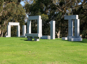
Continuing south is the La Jolla Project.  On the lawn 71 granite blocks are arranged to represent the architectural vocabulary: posts, lintels, columns, arches, windows, doorways and thresholds.


The Red Shoe is hidden in a small grove of eucalyptus trees.  

My favorite of the dozen exhibits I visited was The Wind Garden.  I completely missed it on the way to the Red Shoe.  But the breeze picked up and I could hear the hypnotic melody of wind as I left.  In the light breeze it was enchanting, I have no idea what a windy day might sound like.

As the wind passes through the trees it triggers chimes housed there.  The melody is always unique and never repeats.  I took advantage of the benches there to enjoy the sounds.

As I returned to the Gliderport I could see no less than a dozen ultra-lites riding the thermals.

A long time ago I took hang gliding lessons with the goal of getting to the point where I could sour along the cliffs here.  I never got that good!  But the ultra-lites offer tandem rides, I don't have to be good ... just trusting.


I not that trusting ...

There are more pieces in the Stuart Collection then I visited.  It's certainly an enjoyable way to spend a sunny afternoon on the UCSD campus.